Find your olive grove or oil mill
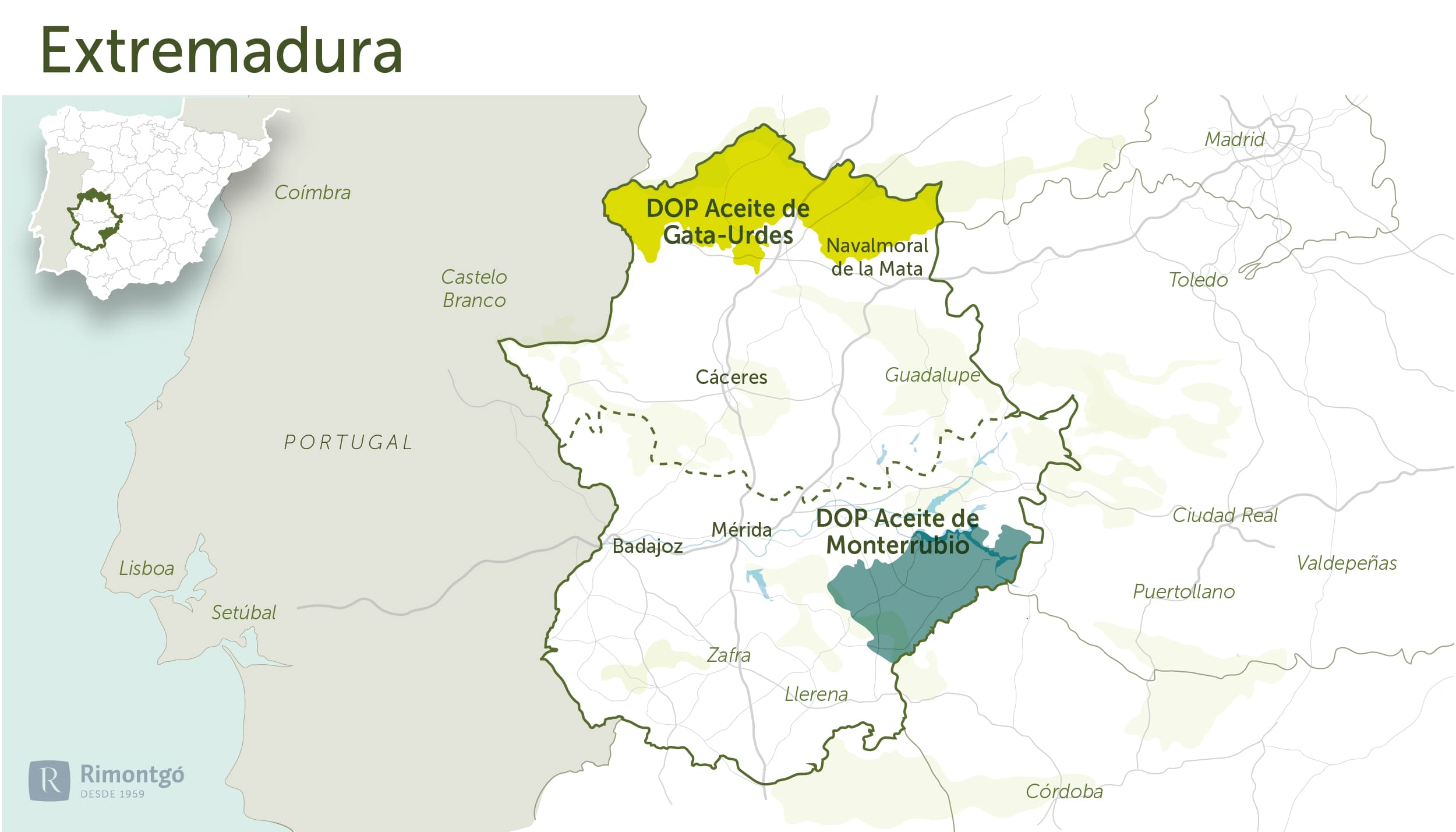
Infographic of the area

Cáceres
In Cáceres, the DO Gata-Hurdes stands out as the only DO for olive trees in the area.
DO Gata-Hurdes
In Cáceres, from the sierras of Gredos, Béjar and Peña de Francia to the Hurdes and Sierra de Gata. The regions covered by the DO are Sierra de Gata, Las Hurdes, Valle del Alagón, Trasierra - Tierras de Granadilla, Valle del Ambroz, Valle del Jerte and La Vera.
Varieties
This DO guarantees exclusively single varietal extra virgin olive oil obtained from the manzanilla cacereña.
The total surface area is around 500,000 hectares. Of this figure, olive trees of the Manzanilla Cacereña variety occupy more than 30,000 hectares, with the Gata-Hurdes region having the largest number (23,418 ha). This is followed by Tierras de Cáceres, with 6,470 ha.
In the Villuercas and La Siberia, Manzanilla Cacereña is also a predominant variety, although its cultivation extends to the south of Salamanca, Ávila and Madrid, adding 16,000 ha to those existing in Cáceres. Olive groves are cultivated from the lowest altitudes up to approximately 800 m above sea level.
History
In the region - in the municipalities of Valverde del Fresno, Eljas, San Martín de Trevejo and Villamiel - some lithic pieces related to the pressing process have been found at sites dating from the Roman period.
From the beginning of the century, Sierra de Gata was the region best known externally for its olive oil. In Hurdes, the olive grove has been and still is the main crop, with a similar antiquity to that of Gata.
Climate and soils
The relief of the area is typical of the sierra, corresponding to the southern slopes of the Cordillera Central, with altitudes ranging from 400 to 2,000 metres. The prolific olive groves of Extremadura cover part of the aforementioned sierras and the rocky units with gentle profiles that rise up between the steep slopes of the Gredos and the Tiétar river trench, and the southern slate system of the Hurdes and the Sierra de Gata. Practically the entire area of the appellation belongs to the Tagus basin. The main fluvial network is formed by the rivers Tietar, Jerte, Eljas and Alagón.
The soils are formed on siliceous materials, mainly granitic rocks, surrounded, in large areas, by slate and sandstone.
The climate in the area is characterised by a warm oat type winter, with the exception of the north-east which, due to the influence of the Gredos area, becomes cool oat type. Summers are Corn type. The average annual rainfall ranges between 600 and 1,300 mm, classifying it as a transition from humid to dry Mediterranean.
Olives
Subscribe to our mailing list to receive news about olive groves and oil mills.


