Find your olive grove or oil mill
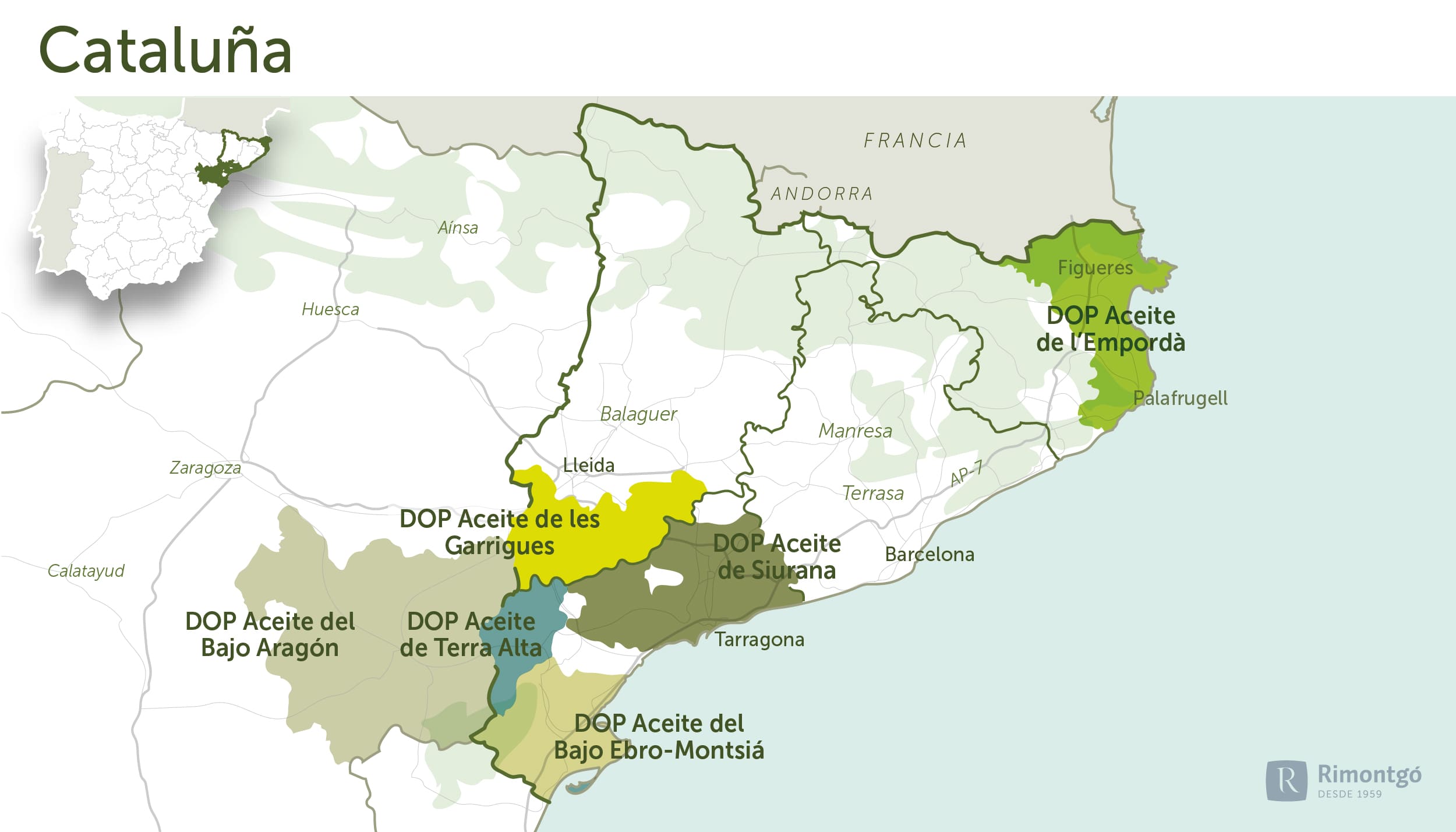
Infographic of the area

Girona
In Girona, the DO Aceite de l'Empordà stands out as the only DO for olive trees in the province.
DO Aceite de l'Empordà
It is located in the counties of L'Alt Empordà and El Baix Empordà, El Gironès and El Pla de l'Estany, in the province of Girona. The surface area of the olive grove is 2,2632.3 hectares, divided by zones: 2,325.0 hectares in L'Alt Empordà, 273.9 hectares in El Baix Empordà, 17.8 hectares in El Pla de l'Estany and 15.6 hectares in El Gironès.
Varieties
The native varieties are argudell, curivell, llei de Cadaqués and arbequina. Their distribution in the olive grove area is argudell 62.73%, arbequina 9.8%, IIei de Cadaqués 7.6% and curivell 1.5%.
The argudell variety is the majority variety, therefore, its presence must be the majority in the oils produced within the PDO, with a minimum percentage of 51%.
History
The first samples of olive trees found in the Empordà date back to the end of the Bronze Age. However, olive growing and oil production are attributed to the Greeks, who arrived by sea in the 6th century BC and founded the colonies of Empúries and Roses.
According to ancient sources, the Empúries area was the supplier of oil to Athens. In fact, numerous Greek vases of the type known as Sant Valentí (5th-4th centuries BC) with the decoration of the olive leaf and the olive blossom have survived.
Later, the Romans maintained the cultivation and the Benedictine monks consolidated it. We know that Benedictine monasteries such as Sant Quirze de Colera and Sant Pere de Rodes had large areas of cultivated land.
The growth of the olive tree in the 18th and 19th centuries was spectacular. At the end of the 19th century, L'Alt Empordà was hit by the phylloxera plague and olive trees were planted where vines had been removed. This led to the current situation, with an extension of more than two thousand hectares of olive trees and a production of high quality olive oil.
Climate and soils
The cultivation area is concentrated on land with poor soils: the Albera and Rodes mountain ranges in the north and the Montgrí and Gavarres mountains in the south. These mountainous substrates form a characteristic geology, with granite, slate and clay. These soils are shallow, with a sandy-loam texture, with an acid or neutral reaction, when they come from the schists, granites or gneiss, characteristic of the Pyrenean foothills. When they come from the calcareous rocks of the Montgrí massif, they are deeper, with a clayey-loam texture and a basic reaction.
The Empordà area can be divided into three geographical zones: the alluvial plain, the areas of marginal elevations and the mountain massifs.
The alluvial plain is formed by the sediments of the rivers that in post-Quaternary times filled the large Pliocene estuaries bounded by the mountain massifs. With the formation of sandy ridges between the Cap de Creus peninsula and the Montgrí massif, and between the latter and the Bagur massif, an enormous lagoon was closed off. This gave rise to a large area of marshland and mudflats with a large number of coastal lagoons. Today we can divide this plain into two sectors: the coastal strip and the inland area.
The coastal strip runs parallel to the coast on both sides of the Montgrí massif and is made up of small lagoons and marshes. They are all generally saline.
The inland area is made up of high-powered alluvial land, rich in phreatic water and of good quality for cultivation, generated by the basins of the Muga, Fluvià and Ter rivers.
The marginal elevations are the areas formed by gentle undulations that come from the mountain ranges that frame the flood plain. Palaeozoic or Mesozoic terminals formed by chains of rounded elevations and erosion terraces in the process of pre-plainisation at the foot of these (Albera mountain range, Rodes mountain range, Les Gavarres, El Montgrí, Bagur massif).
The mountain massifs define three distinct relief units: the mountain ranges that border the region to the north (the eastern end of the Pyrenees), the one that borders it to the south (the northern end of the Catalan Coastal Range) and a massif that rises in the middle of the alluvial plain, close to the sea (El Montgrí).
The privileged geographical location of Empordà, halfway between the Mediterranean Sea and the Pyrenees, means that the climate combines mild winters, not very hot summers and the inevitable tramuntana (north wind).
Temperatures are moderated by the regulating effect of the sea, as is the daily temperature range. The average annual temperature is 14.6 ºC. The extreme values at the Figueres observatory are 38 ºC in summer and -6 ºC in winter.
Olives
Subscribe to our mailing list to receive news about olive groves and oil mills.


